Repeatedly, Iran and Oman are close to a “deal” that would let Tehran meter the Strait of Hormuz — a “toll in all but name,” the world’s shipping lines warn. Strip away the headlines and it is the oldest quarrel in maritime law: whether anyone may fence the open sea. This is the first in a series charting the invisible lines that divide the water, and why they reach all the way to the Texas coast.
There is an ancient idea — older than any flag now flying — that the sea belongs to no one, and therefore, to everyone. But, it is being tested again, month after month, in the twenty-one-mile-wide gap of water between Iran and Oman.
After United States (U.S.)–Israeli strikes at the end of February 2026 touched off a war that shut the Strait of Hormuz — the chokepoint through which roughly a fifth of the world’s oil normally moves — Iran and Oman now are close to a “deal” to reopen it. Under the proposal, inbound ships would run an Iranian lane and outbound ships an Omani one, with Tehran recognized, in effect, as the strait’s gatekeeper.
Iran has floated charging between 5 and 7 percent of a cargo’s value to pass; Oman has discussed roughly 3 percent; Naturally, Washington (and the rest of the free world) wants no fee at all. Iran calls its version a “service fee” for security and the environment. Eight of the world’s largest shipping associations, in a joint letter to the United Nations’ (UN) shipping agency, called it something plainer: a “toll in all but name.”
The bind tightened in late July, when the Lloyd’s Market Association (LMA) — the body that speaks for the underwriters of the Lloyd’s of London insurance market — issued a war-risk clause that voids a ship’s coverage the moment she pays any Hormuz transit fee. Pay Tehran and lose your insurance; refuse and you may not be allowed to sail. Owners now sit, as one insurer put it, in a “catch-22,” with a fragile ceasefire set to lapse around August 12.
Behind the money is a question lawyers have argued for four centuries: may a coastal nation charge the world for the right to pass? Answering it — and understanding why it matters to a deckhand on the Houston Ship Channel as much as to a tankerman off Bandar Abbas — means knowing where the lines in the water are drawn, and who drew them. This is the first post in a short series on exactly that.
The Free Sea: A Four-Hundred-Year-Old Argument
In 1609 a young Dutch jurist named Hugo Grotius published “Mare Liberum” — “The Free Sea” — arguing that the ocean, unlike land, could belong to no nation, because it could be neither occupied nor fenced.
The competing English answer, “Mare Clausum” (“The Closed Sea”), held that a sovereign could indeed claim the waters off its coast. Modern law is the truce between the two: a nation owns a ribbon of sea near its shore, and beyond that ribbon the water grows freer the farther out you go.
That principle of unimpeded movement — “freedom of navigation” — is today written into Article 87 of the United Nations Convention on the Law of the Sea (UNCLOS), the 1982 treaty that most of the world, and by custom, even non-parties like the United States, treats as the ultimate rulebook of the oceans.
From the Beach to the Blue: The Zones of the Sea
Picture standing on a Galveston jetty and walking straight out to sea. Under UNCLOS you would cross, in order, four zones, each with its own rules:
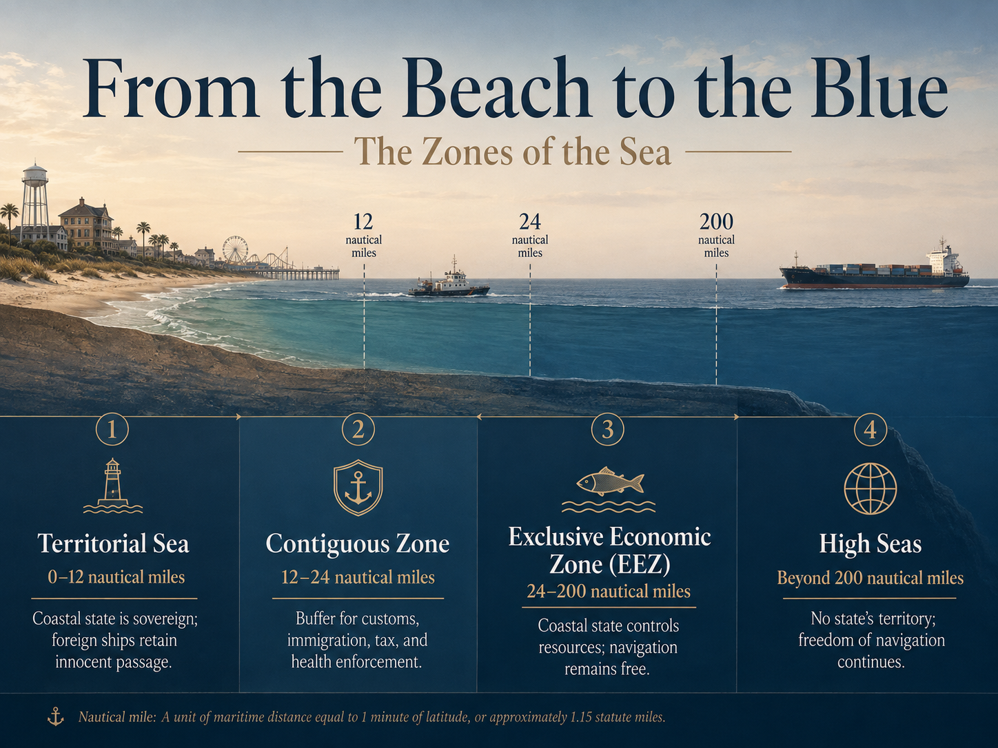
- The territorial sea— out to 12 nautical miles (nm) from the coast. Here the coastal state is sovereign, nearly as it is on land, but foreign ships keep a right of innocent passage: they may pass through so long as they do so peacefully and without lingering.
- The contiguous zone— out to 24 nm. Not sovereign water, but a buffer where a nation may still enforce its customs, immigration, tax, and health laws.
- The exclusive economic zone (EEZ)— out to 200 nm. Here the coastal state owns the resources — the fish, the oil, the wind — but not the water itself: every other nation keeps its freedom of navigation across it.
- The high seas— everything beyond. No one’s and everyone’s, governed mainly by the flag a ship flies. This is Grotius’s free sea, still intact.
When Coasts Collide: The Strait Problem
That tidy picture breaks down wherever two countries sit closer than 24 nm apart — because their 12-mile territorial seas overlap and swallow the water between them. The Strait of Hormuz is exactly such a place: barely twenty-one miles wide at the neck, with every shipping lane running through Iranian or Omani territorial waters. If ordinary sovereignty applied, the two nations could simply bar the door.
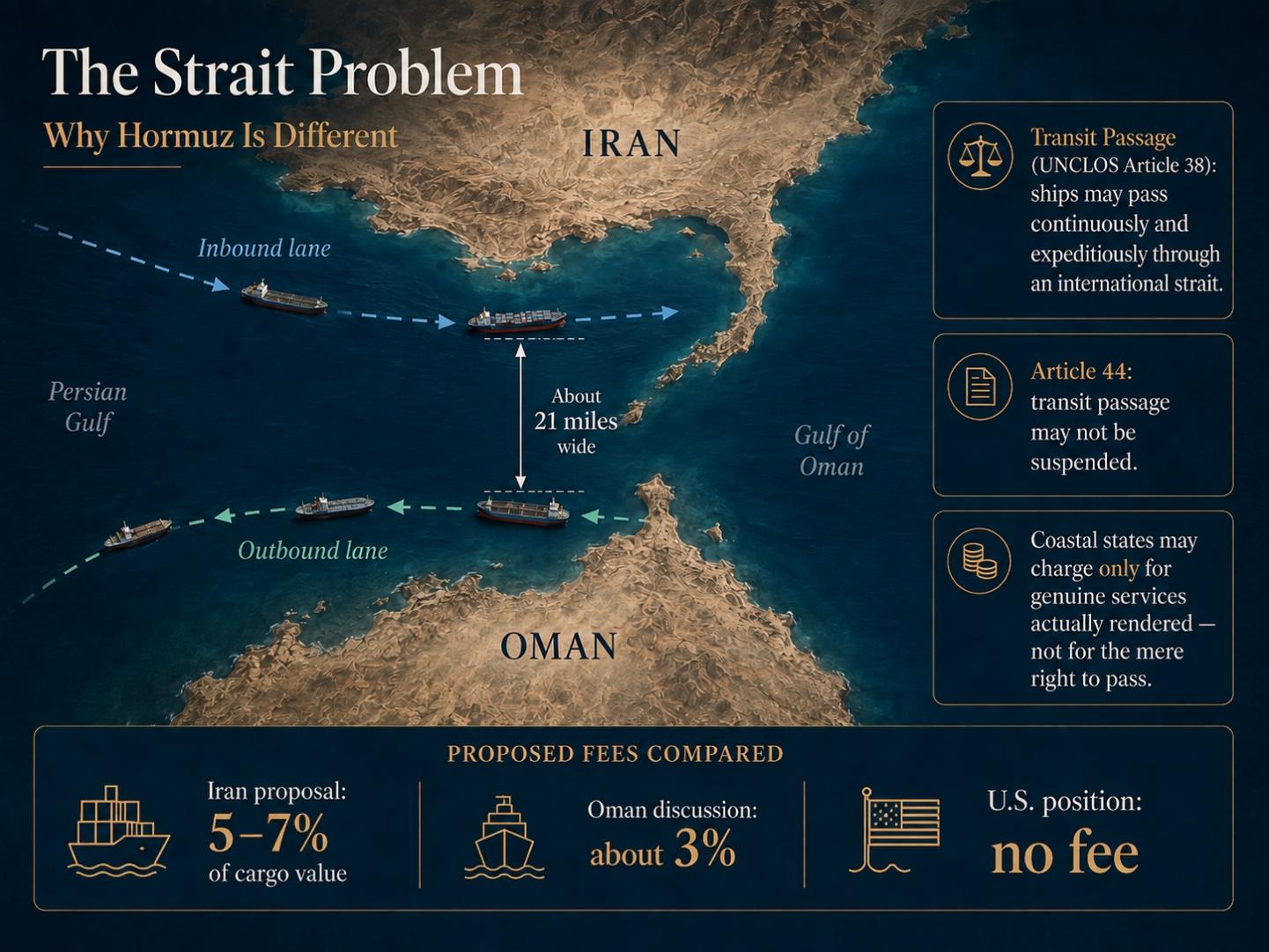
UNCLOS anticipated this. For straits used for international navigation it created a right stronger than innocent passage, called transit passage (Article 38): all ships may pass “continuously and expeditiously,” and — critically — Article 44 commands that “there shall be no suspension of transit passage.” A coastal state may organize traffic and protect its waters, and it may charge for genuine services actually rendered to a ship, without discrimination (the principle of Article 26).
What it may not do is set up a booth and bill the world for the mere right to cross. The International Court of Justice said as much in the 1949 Corfu Channel case: sovereignty over an international strait does not include the power to make passage conditional. That is why the shipping lines’ phrase — a “toll in all but name” — is less rhetoric than legal accusation.
There is a complication, however. Iran signed UNCLOS but never ratified it, and the United States never joined at all. Yet both have long treated the core navigation rules as customary international law binding on everyone — which is why Washington insists on total freedom of commercial navigation through Hormuz, and why the International Maritime Organization (IMO) Council reminded the region this summer that passage must remain “non-discriminatory and unimpeded” and free of any tolls and charges.
The firm has tracked this story as it developed — from Tehran’s move to stand up a Persian Gulf Strait Authority (PGSA) and meter the water, to the quiet pressure on masters to run the strait “dark”, to what a foreign warning about the right of passage means for the crews who actually sail it.
The Texas Twist: Three Marine Leagues
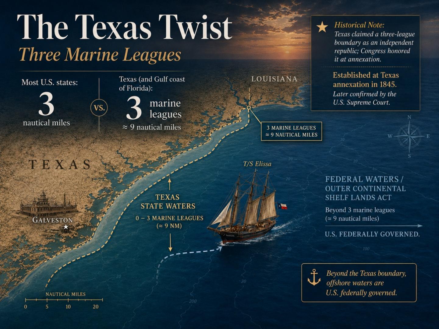
The same argument — where does one authority end and the next begin — runs right through our own coast, only more quietly. Most American states own the seabed and waters out to just 3 nm under the Submerged Lands Act (SLA) of 1953. Texas is one of two exceptions (the Gulf coast of Florida is the other): our line runs three marine leagues — about 9 nm — out into the Gulf.
The reason is history. When Texas was an independent republic, it claimed a three-league boundary; Congress honored it at annexation in 1845, and the U.S. Supreme Court confirmed it in United States v. Louisiana (1960). Beyond that line the water becomes federal, governed by the Outer Continental Shelf Lands Act (OCSLA). So when the T/S Elissa, Galveston’s square-rigged 1877 tall ship, stands out past the sea buoy, she crosses from Texas water into United States water at a line first drawn by a vanished republic.
Those lines are not just trivia. Which side of them an injury happens on can decide which body of law applies, which court hears the case, and what an injured mariner or worker is owed. That is the thread this series will follow.
Why This Reaches the Gulf Coast
Whether the water is metered off Bandar Abbas or mapped off the Bolivar Peninsula, the questions are the same: Who owns this stretch of sea? Who may charge for it, stop you on it, or order you across it? Freedom of navigation is no abstraction to a Houston Ship Channel pilot, a barge crew on the Gulf Intracoastal Waterway, or a charter captain crossing Galveston Bay — it is the difference between a working day and a stranded one. And when a coastal power tries to fence the water, it is the mariner, as always, who is caught in the gap.
Our law firm has written before about how far a nation may reach when it expands its claims over navigation, and about the legal concepts every mariner and passenger on the high seas should know.
The oldest rule of the sea is also the simplest: the water moves, and so should those who work it. The lines we draw upon it should make that passage safer — not turn a strait into a toll road.
Maritime Trivia Question!
Q: We measure Texas’s Gulf boundary in marine leagues and most states’ in miles — but why did “three miles” become the world’s border at sea in the first place?
A: For centuries the answer was gunpowder. Under what jurists called the cannon-shot rule — captured in the Dutch scholar Cornelius van Bynkershoek’s 1702 own maxim “terrae dominium finitur ubi finitur armorum vis”, “the dominion of the land ends where the power of arms ends” — a nation’s waters reached only as far as it could defend them from shore: roughly the range of an eighteenth-century coastal cannon. That distance hardened into the famous three-mile limit (and, reckoned in leagues, the very line Texas still claims today).
We at the Herd Law Firm are proud to fight for seamen, maritime workers, shippers, and passengers in all types of personal injury, death, and maritime commercial claims. As maritime attorneys (and sailors ourselves!) located in northwest Houston, we never waver in our commitment to help maritime workers, businesses, and their families when they are injured, mistreated, or shortchanged.
The information in this post is for general informational purposes only and does not constitute legal advice. For questions specific to your maritime law issue, please contact us at 713-955-3699, at Charles.Herd@HerdLawFirm.com, or at our office at 8826 Louetta Road, Suite 310, Spring, Texas 77379.
Sources
1. Saul, Jonathan. “Proposed Hormuz Passage Deal Not Feasible for Shipping Industry, Sources Say.” Reuters, Aug. 7, 2026. insurancejournal.com
2. “Iran, Oman, US ‘close’ to Hormuz deal: What do they all want?” Al Jazeera, Aug. 5, 2026. aljazeera.com
3. “Iran Says It Has a Deal to Reopen the Strait of Hormuz — and Shipowners Are Outraged by Its Plan to Charge Fees.” Fortune, Aug. 6, 2026. fortune.com
4. United Nations. United Nations Convention on the Law of the Sea (1982), Part III (Arts. 37–44) and Art. 26. un.org
5. “Codifying Coercion: Iran’s ‘New Legal Regime’ and the Law of International Straits.” EJIL: Talk!, Apr. 2026. ejiltalk.org
6. Bureau of Ocean Energy Management. “Federal Offshore Lands” (Submerged Lands Act; three-marine-league exception for Texas and west-coast Florida; OCSLA). boem.gov
7. United States v. Louisiana (Texas Boundary Case), 394 U.S. 1 (1969), affirming Texas’s three-league Gulf boundary under United States v. Louisiana, 363 U.S. 1 (1960). govinfo.gov
8. Florida Sea Grant. “Understanding Florida’s State Waters: Why the Gulf Boundary Extends 9 Nautical Miles” (history of the Texas and Florida three-league lines). flseagrant.org